
Thank you for supporting this site ❤️
Make a donation
Make a donation
Benton Township topographic map
Click on the map to display elevation.
Thank you for supporting this site ❤️
Make a donation
Make a donation
About this map
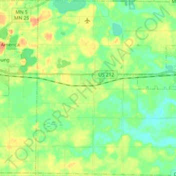
Name: Benton Township topographic map, elevation, terrain.
Location: Benton Township, Carver County, Minnesota, United States (44.71700 -93.89020 44.80479 -93.76775)
Average elevation: 296 m
Minimum elevation: 281 m
Maximum elevation: 319 m
Thank you for supporting this site ❤️
Make a donation
Make a donation
Other topographic maps
Click on a map to view its topography, its elevation and its terrain.
Thank you for supporting this site ❤️
Make a donation
Make a donation
New Germany
United States > Minnesota > Carver County > New Germany > New Germany
Average elevation: 298 m