
Thank you for supporting this site ❤️
Make a donation
Make a donation
Penhas topographic map
Click on the map to display elevation.
Thank you for supporting this site ❤️
Make a donation
Make a donation
About this map
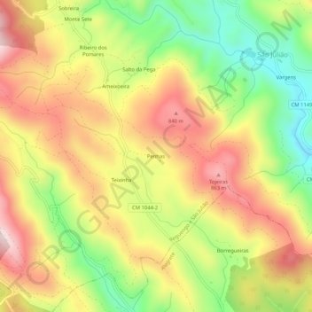
Name: Penhas topographic map, elevation, terrain.
Location: Penhas, Reguengo e São Julião, Portalegre, 7300-321, Portugal (39.27720 -7.33954 39.31720 -7.29954)
Average elevation: 678 m
Minimum elevation: 454 m
Maximum elevation: 888 m
Thank you for supporting this site ❤️
Make a donation
Make a donation
Other topographic maps
Click on a map to view its topography, its elevation and its terrain.
Thank you for supporting this site ❤️
Make a donation
Make a donation
Alegrete
Portugal > Portalegre > Portalegre
Inserida em pleno Parque Natural da Serra de São Mamede, a uma altitude de 500 m, localiza-se a cerca de 2 km da margem direita da ribeira de Alegrete, caracterizada por uma enorme diversidade geológica, paisagística, faunística e florística.
Average elevation: 492 m
Thank you for supporting this site ❤️
Make a donation
Make a donation