
Thank you for supporting this site ❤️
Make a donation
Make a donation
Ratliff City topographic map
Click on the map to display elevation.
Thank you for supporting this site ❤️
Make a donation
Make a donation
About this map
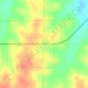
Name: Ratliff City topographic map, elevation, terrain.
Location: Ratliff City, Carter County, Oklahoma, United States (34.44150 -97.52727 34.45607 -97.50554)
Average elevation: 315 m
Minimum elevation: 288 m
Maximum elevation: 337 m
Thank you for supporting this site ❤️
Make a donation
Make a donation
Other topographic maps
Click on a map to view its topography, its elevation and its terrain.