
Thank you for supporting this site ❤️
Make a donation
Make a donation
Saunders Lake topographic map
Click on the map to display elevation.
Thank you for supporting this site ❤️
Make a donation
Make a donation
About this map
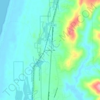
Name: Saunders Lake topographic map, elevation, terrain.
Location: Saunders Lake, Coos County, Oregon, United States (43.50516 -124.23694 43.54516 -124.19694)
Average elevation: 35 m
Minimum elevation: 0 m
Maximum elevation: 170 m
Thank you for supporting this site ❤️
Make a donation
Make a donation
Other topographic maps
Click on a map to view its topography, its elevation and its terrain.