
Chinon topographic map
Click on the map to display elevation.
Chinon
Topography has played a major role: the formerly fortified town was developed at the foot of the castle on the rocky outcrop, protecting the northern side, with the Vienne River in the south. Apart from the natural defensive protection on both sides, this fact makes a long narrow urban space, with the main streets running parallel to the river.
About this map
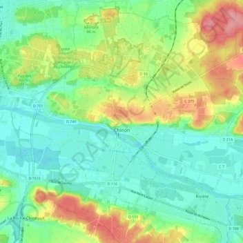
Name: Chinon topographic map, elevation, terrain.
Average elevation: 58 m
Minimum elevation: 24 m
Maximum elevation: 124 m