
Make a donation
Hausach topographic map
Click on the map to display elevation.
Make a donation
About this map
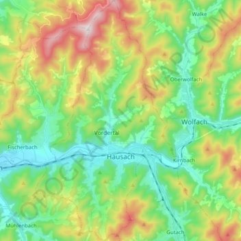
Name: Hausach topographic map, elevation, terrain.
Average elevation: 461 m
Minimum elevation: 214 m
Maximum elevation: 946 m
Make a donation
Other topographic maps
Click on a map to view its topography, its elevation and its terrain.
Hornisgrinde
Duitsland > Baden-Württemberg > Ortenaukreis > Sasbachwalden
De Hornisgrinde is een berg in Nationaal Park Schwarzwald in de deelstaat Baden-Württemberg, Duitsland. De berg heeft een hoogte van 1.163 meter en is gelegen in het Zwarte Woud.
Average elevation: 968 m
Bermersbach
Duitsland > Baden-Württemberg > Ortenaukreis > Gengenbach > Strohbach
Average elevation: 296 m
Make a donation
Heiligenreute
Duitsland > Baden-Württemberg > Ortenaukreis > Berghaupten > Heiligenreute
Average elevation: 259 m
Urenkopfturm
Duitsland > Baden-Württemberg > Ortenaukreis > Haslach im Kinzigtal
Average elevation: 339 m