
Thank you for supporting this site ❤️
Make a donation
Make a donation
Calanasan topographic map
Click on the map to display elevation.
Thank you for supporting this site ❤️
Make a donation
Make a donation
Calanasan
The town's topography or slope is predominantly rugged and mountainous with sporadic flood plains and plateaus. The municipality cradles the larger part of the Apayao-Abulog watershed area as the main source of streams that fills the mighty river which originates from the municipality.
Thank you for supporting this site ❤️
Make a donation
Make a donation
About this map
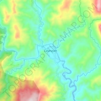
Name: Calanasan topographic map, elevation, terrain.
Location: Calanasan, Apayao, 3814, Philippines (18.21511 121.00349 18.29511 121.08349)
Average elevation: 524 m
Minimum elevation: 246 m
Maximum elevation: 1,172 m
Thank you for supporting this site ❤️
Make a donation
Make a donation
Other topographic maps
Click on a map to view its topography, its elevation and its terrain.