
Thank you for supporting this site ❤️
Make a donation
Make a donation
Oudenaken topographic map
Click on the map to display elevation.
Thank you for supporting this site ❤️
Make a donation
Make a donation
Oudenaken
Oudenaken ligt in het Pajottenland op een hoogte van 30-57,5 meter. Oudenaken wordt in het zuiden begrensd door de Zuunbeek.
Thank you for supporting this site ❤️
Make a donation
Make a donation
About this map
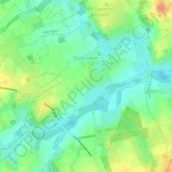
Name: Oudenaken topographic map, elevation, terrain.
Average elevation: 41 m
Minimum elevation: 24 m
Maximum elevation: 68 m
Thank you for supporting this site ❤️
Make a donation
Make a donation
Other topographic maps
Click on a map to view its topography, its elevation and its terrain.
Sobroek
België > Vlaams-Brabant > Halle-Vilvoorde > Sint-Pieters-Leeuw > Vlezenbeek
Average elevation: 42 m