
Thank you for supporting this site ❤️
Make a donation
Make a donation
Saint-Pierre topographic map
Click on the map to display elevation.
Thank you for supporting this site ❤️
Make a donation
Make a donation
About this map
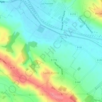
Name: Saint-Pierre topographic map, elevation, terrain.
Average elevation: 176 m
Minimum elevation: 147 m
Maximum elevation: 238 m
Thank you for supporting this site ❤️
Make a donation
Make a donation
Other topographic maps
Click on a map to view its topography, its elevation and its terrain.
Bergnac
Frankrijk > Occitanië > Haute-Garonne > Sainte-Foy-d'Aigrefeuille > Bergnac
Average elevation: 190 m