
Thank you for supporting this site ❤️
Make a donation
Make a donation
Naujan Lake topographic map
Click on the map to display elevation.
Thank you for supporting this site ❤️
Make a donation
Make a donation
Naujan Lake
Mount Naujan, elevation 1,380 feet (420 m) and one of the inactive volcanoes of the country, is situated northeast of the geographic center of the lake. Several thermal springs and solfataras are reported to exist on the eastern border of the Naujan Lake.
Thank you for supporting this site ❤️
Make a donation
Make a donation
About this map
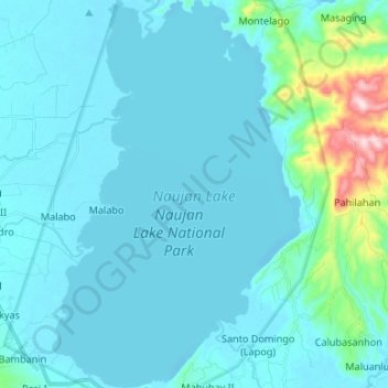
Name: Naujan Lake topographic map, elevation, terrain.
Location: Naujan Lake, Malabo, Oriental Mindoro, Mimaropa, Philippines (13.10792 121.30381 13.23755 121.38926)
Average elevation: 46 m
Minimum elevation: -4 m
Maximum elevation: 461 m
Thank you for supporting this site ❤️
Make a donation
Make a donation