
Make a donation
Schwürbitz topographic map
Click on the map to display elevation.
Make a donation
Schwürbitz
Schwürbitz liegt am Main, auf einer Höhe von 287 m ü. NHN und hat 1446 Einwohner (Stand: 30. Juni 2017). Es liegt am nördlichsten Punkt des Mains.
Make a donation
About this map
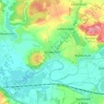
Name: Schwürbitz topographic map, elevation, terrain.
Average elevation: 292 m
Minimum elevation: 259 m
Maximum elevation: 367 m
Make a donation
Other topographic maps
Click on a map to view its topography, its elevation and its terrain.
Lichtenfels
Deutschland > Bayern > Landkreis Lichtenfels
Bohnberg | Buch am Forst | Burgberg | Degendorf | Eichig | Friesenhof | Gnellenroth | Hammer | Heinach | Isling | Karolinenhöhe | Klosterlangheim | Kösten | Köttel | Krappenroth | Lahm | Mistelfeld | Mönchkröttendorf | Nassanger | Oberlangheim | Oberwallenstadt | Reundorf | Roth | Rothmannsthal | Schney |…
Average elevation: 348 m