
Thank you for supporting this site ❤️
Make a donation
Make a donation
Greenhead topographic map
Click on the map to display elevation.
Thank you for supporting this site ❤️
Make a donation
Make a donation
About this map
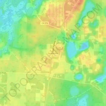
Name: Greenhead topographic map, elevation, terrain.
Location: Greenhead, Washington County, Florida, United States (30.48464 -85.67993 30.52464 -85.63993)
Average elevation: 38 m
Minimum elevation: 17 m
Maximum elevation: 55 m
Thank you for supporting this site ❤️
Make a donation
Make a donation
Other topographic maps
Click on a map to view its topography, its elevation and its terrain.