
Thank you for supporting this site ❤️
Make a donation
Make a donation
Hartland topographic map
Click on the map to display elevation.
Thank you for supporting this site ❤️
Make a donation
Make a donation
About this map
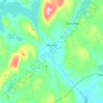
Name: Hartland topographic map, elevation, terrain.
Location: Hartland, Somerset County, Maine, 04943, United States (44.81210 -69.61497 44.93896 -69.43921)
Average elevation: 111 m
Minimum elevation: 59 m
Maximum elevation: 295 m
Thank you for supporting this site ❤️
Make a donation
Make a donation
Other topographic maps
Click on a map to view its topography, its elevation and its terrain.
Jones Pond
United States > Maine > Somerset County > Bald Mountain Township T4 R3
Average elevation: 503 m