
Thank you for supporting this site ❤️
Make a donation
Make a donation
Calloway Peak topographic map
Click on the map to display elevation.
Thank you for supporting this site ❤️
Make a donation
Make a donation
About this map
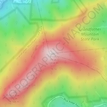
Name: Calloway Peak topographic map, elevation, terrain.
Average elevation: 1,496 m
Minimum elevation: 1,173 m
Maximum elevation: 1,789 m
Thank you for supporting this site ❤️
Make a donation
Make a donation
Other topographic maps
Click on a map to view its topography, its elevation and its terrain.
Cajah's Mountain
United States > North Carolina > Caldwell County
Cajah's Mountain is located in southern Caldwell County. It is bordered to the north by Lenoir, the county seat. Cajah Mountain's highest elevation 1,530 feet (470 m), is at the southern end of the town next to Connelly Springs Road, the major north–south road through the town.
Average elevation: 390 m
Thank you for supporting this site ❤️
Make a donation
Make a donation