
Thank you for supporting this site ❤️
Make a donation
Make a donation
Mace topographic map
Click on the map to display elevation.
Thank you for supporting this site ❤️
Make a donation
Make a donation
About this map
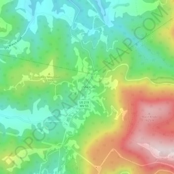
Name: Mace topographic map, elevation, terrain.
Location: Mace, Pocahontas County, West Virginia, 26291, United States (38.43623 -80.05062 38.47623 -80.01062)
Average elevation: 1,103 m
Minimum elevation: 893 m
Maximum elevation: 1,460 m
Thank you for supporting this site ❤️
Make a donation
Make a donation
Other topographic maps
Click on a map to view its topography, its elevation and its terrain.
Green Bank Telescope
United States > West Virginia > Pocahontas County
As an azimuth-elevation mounting telescope, the azimuth adjustments are driven by four trucks with four wheels each on a 210-foot (64 m) diameter rail. The 16 thirty-horsepower motors can change azimuth at the rate of up to 40 degrees per minute. Azimuth axis is also supported by a pintle bearing at the center…
Average elevation: 822 m