
Thank you for supporting this site ❤️
Make a donation
Make a donation
Teufelskopf topographic map
Click on the map to display elevation.
Thank you for supporting this site ❤️
Make a donation
Make a donation
Teufelskopf
Der Teufelskopf ist laut einem auf topographischen Karten verzeichneten trigonometrischem Punkt im Bereich des Senders Teufelskopf mindestens 695 m hoch. Wenige Meter südwestlich vom Gipfel befindet sich eine 694,3 m hohe Stelle. Im Südwesten der Gipfelregion ist auf derartigen Karten etwa in Ovalform eine 695-m-Höhenlinie ohne weitere Höhenangabe zu finden, so dass es möglich ist, dass die Erhebung im Inneren dieses Ovals noch etwas höher als 695 m ist. Etwas ostnordöstlich des Gipfels liegt eine Waldwegkreuzung auf 685 m Höhe.
Thank you for supporting this site ❤️
Make a donation
Make a donation
About this map
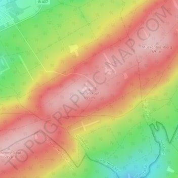
Name: Teufelskopf topographic map, elevation, terrain.
Average elevation: 610 m
Minimum elevation: 473 m
Maximum elevation: 701 m
Thank you for supporting this site ❤️
Make a donation
Make a donation