
Thank you for supporting this site ❤️
Make a donation
Make a donation
Cathers Lake topographic map
Click on the map to display elevation.
Thank you for supporting this site ❤️
Make a donation
Make a donation
About this map
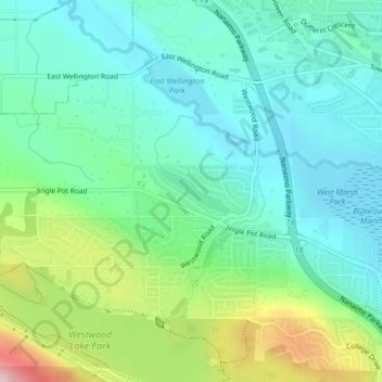
Name: Cathers Lake topographic map, elevation, terrain.
Average elevation: 119 m
Minimum elevation: 54 m
Maximum elevation: 293 m
Thank you for supporting this site ❤️
Make a donation
Make a donation
Other topographic maps
Click on a map to view its topography, its elevation and its terrain.
Departure Bay
Canada > British Columbia > Regional District of Nanaimo > Nanaimo
Average elevation: 30 m
Linley Valley
Canada > British Columbia > Regional District of Nanaimo > Nanaimo
Average elevation: 76 m
Protection Island
Canada > British Columbia > Regional District of Nanaimo > Nanaimo
Average elevation: 5 m
Outer Nanaimo Harbour
Canada > British Columbia > Regional District of Nanaimo > Nanaimo
Average elevation: 7 m
Thank you for supporting this site ❤️
Make a donation
Make a donation
Beach Estates Park
Canada > British Columbia > Regional District of Nanaimo > Nanaimo
Average elevation: 47 m