
Thank you for supporting this site ❤️
Make a donation
Make a donation
Amelith topographic map
Click on the map to display elevation.
Thank you for supporting this site ❤️
Make a donation
Make a donation
Amelith
Die Ansiedlung liegt im südlichen Solling im Tal des Reiherbachs. Sie ist umgeben von waldreichen Höhen.
Thank you for supporting this site ❤️
Make a donation
Make a donation
About this map
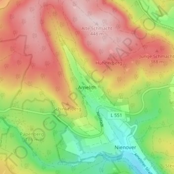
Name: Amelith topographic map, elevation, terrain.
Average elevation: 313 m
Minimum elevation: 165 m
Maximum elevation: 452 m
Thank you for supporting this site ❤️
Make a donation
Make a donation