
Make a donation
Homyel topographic map
Click on the map to display elevation.
Make a donation
Homyel
The terrain on which the city as a whole is built, is flat. On the right bank of the river, is a gradually decreasing plain water-glacial and fluvial terrace of the Sozh river. The left bank is a low-lying alluvial plain. The highest elevation of 144 meters above sea level is found on the northern outskirts of Gomel, the lowest elevation of 115 m at the water boundary of the Sozh. Novobelitskiy district, which is located on the left bank of the river (i.e., towards the south), has elevations averaging 10–15 meters lower than the northern and central parts of the city. On the left bank of the Sozh many kilometers of beaches can be found.
Make a donation
About this map
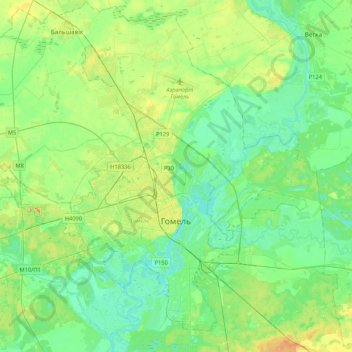
Name: Homyel topographic map, elevation, terrain.
Location: Homyel, Homyel Region, Belarus (52.34327 30.74695 52.57079 31.17153)
Average elevation: 130 m
Minimum elevation: 109 m
Maximum elevation: 186 m
Make a donation
Other topographic maps
Click on a map to view its topography, its elevation and its terrain.
Dnieper
Belarus > Homyel Region > Brahin District > Новаялчанскі сельскі Савет
The source of the Dnieper is the sedge bogs (Akseninsky Mokh) of the Valdai Hills in central Russia, at an elevation of 220 m (720 ft). For 115 km (71 mi) of its length, it serves as the border between Belarus and Ukraine. Its estuary, or liman, used to be defended by the strong fortress of Ochakiv.
Average elevation: 106 m