
Freshwater topographic map
Interactive map
Click on the map to display elevation.
About this map
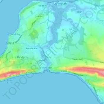
Name: Freshwater topographic map, elevation, terrain.
Location: Freshwater, Isle of Wight, Engeland, Verenigd Koninkrijk (50.65151 -1.53881 50.70734 -1.46059)
Average elevation: 15 m
Minimum elevation: -4 m
Maximum elevation: 145 m
Other topographic maps
Click on a map to view its topography, its elevation and its terrain.
Nettlestone
Verenigd Koninkrijk > Engeland > Isle of Wight > Nettlestone
Nettlestone, Isle of Wight, Engeland, PO34 5JQ, Verenigd Koninkrijk
Average elevation: 15 m