
Make a donation
Sora topographic map
Click on the map to display elevation.
Make a donation
Sora
Above the town on a precipitous rock, elevation 540 metres (1,770 ft), that guards the Liri's valley and the entrance to the Abruzzi are remains of polygonal walls; here, possibly, was the citadel of the original Volscian town. Also, remains of medieval fortifications are there.
Make a donation
About this map
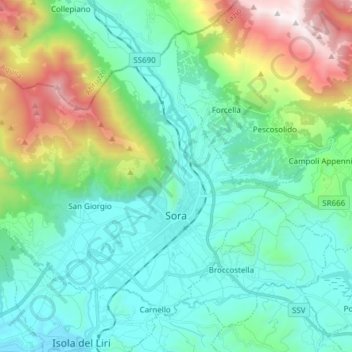
Name: Sora topographic map, elevation, terrain.
Location: Sora, Frosinone, Lazio, 03039, Italy (41.68789 13.50279 41.77808 13.65464)
Average elevation: 605 m
Minimum elevation: 209 m
Maximum elevation: 1,881 m
Make a donation
Other topographic maps
Click on a map to view its topography, its elevation and its terrain.
Monte Cassino
Italy > Lazio > Frosinone > Cassino
Monte Cassino (today usually spelled Montecassino) is a rocky hill about 130 kilometres (80 mi) southeast of Rome, in the Latin Valley, Italy, 2 kilometres (1+1⁄4 mi) west of Cassino and at an elevation of 520 m (1,710 ft). Site of the Roman town of Casinum, it is widely known for its abbey, the first house…
Average elevation: 231 m