
Thank you for supporting this site ❤️
Make a donation
Make a donation
Wiembeck topographic map
Click on the map to display elevation.
Thank you for supporting this site ❤️
Make a donation
Make a donation
About this map
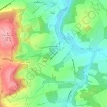
Name: Wiembeck topographic map, elevation, terrain.
Location: Wiembeck, Lemgo, Kreis Lippe, Nordrhein-Westfalen, Deutschland (51.97586 8.93087 52.00274 8.97249)
Average elevation: 166 m
Minimum elevation: 113 m
Maximum elevation: 255 m
Thank you for supporting this site ❤️
Make a donation
Make a donation
Other topographic maps
Click on a map to view its topography, its elevation and its terrain.
Lüerdisser Bruch
Deutschland > Nordrhein-Westfalen > Kreis Lippe > Lemgo > Lüerdissen
Average elevation: 212 m
Thank you for supporting this site ❤️
Make a donation
Make a donation
Luherheide
Deutschland > Nordrhein-Westfalen > Kreis Lippe > Lemgo > Lüerdissen
Average elevation: 170 m
Vogelhorst
Deutschland > Nordrhein-Westfalen > Kreis Lippe > Lemgo > Voßheide
Average elevation: 143 m