
Leeds topographic map
Interactive map
Click on the map to display elevation.
About this map
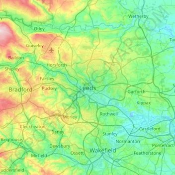
Name: Leeds topographic map, elevation, terrain.
Average elevation: 94 m
Minimum elevation: 7 m
Maximum elevation: 389 m
Other topographic maps
Click on a map to view its topography, its elevation and its terrain.
Pudsey
Verenigd Koninkrijk > Engeland > West Yorkshire > Leeds > Pudsey
Pudsey, Leeds, West Yorkshire, Yorkshire and the Humber, Engeland, LS28 7LH, Verenigd Koninkrijk
Average elevation: 128 m