
Thank you for supporting this site ❤️
Make a donation
Make a donation
Long Hanborough topographic map
Click on the map to display elevation.
Thank you for supporting this site ❤️
Make a donation
Make a donation
About this map
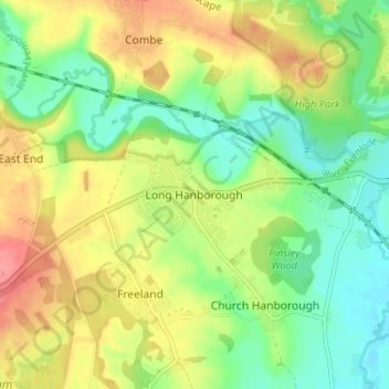
Name: Long Hanborough topographic map, elevation, terrain.
Average elevation: 95 m
Minimum elevation: 63 m
Maximum elevation: 135 m
Thank you for supporting this site ❤️
Make a donation
Make a donation
Other topographic maps
Click on a map to view its topography, its elevation and its terrain.
Charlbury
United Kingdom > England > Oxfordshire > West Oxfordshire > Charlbury
Average elevation: 132 m
Chipping Norton
United Kingdom > England > Oxfordshire > West Oxfordshire > Chipping Norton
Average elevation: 194 m