
Thank you for supporting this site ❤️
Make a donation
Make a donation
Kinniya topographic map
Click on the map to display elevation.
Thank you for supporting this site ❤️
Make a donation
Make a donation
About this map
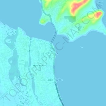
Name: Kinniya topographic map, elevation, terrain.
Location: Kinniya, Trincomalee District, Eastern Province, Sri Lanka (8.48165 81.17122 8.52165 81.21122)
Average elevation: 6 m
Minimum elevation: -1 m
Maximum elevation: 78 m
Thank you for supporting this site ❤️
Make a donation
Make a donation
Other topographic maps
Click on a map to view its topography, its elevation and its terrain.
Thank you for supporting this site ❤️
Make a donation
Make a donation
Scrubs to the east of Nuwaragala
Sri Lanka > Eastern Province > Nuwaragalathenna
Average elevation: 87 m
Thank you for supporting this site ❤️
Make a donation
Make a donation