
Thank you for supporting this site ❤️
Make a donation
Make a donation
La Fossère topographic map
Click on the map to display elevation.
Thank you for supporting this site ❤️
Make a donation
Make a donation
About this map
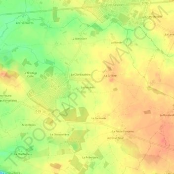
Name: La Fossère topographic map, elevation, terrain.
Average elevation: 69 m
Minimum elevation: 39 m
Maximum elevation: 86 m
Thank you for supporting this site ❤️
Make a donation
Make a donation
Other topographic maps
Click on a map to view its topography, its elevation and its terrain.
85600
France > Pays de la Loire > Vendée > Montaigu-Vendée > La Guyonnière > Le Bordage Caillé
Average elevation: 62 m