Boyolali topographic map
Interactive map
Click on the map to display elevation.
About this map
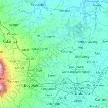
Name: Boyolali topographic map, elevation, terrain.
Location: Boyolali, Central Java, Indonesia (-7.63505 110.38006 -7.13913 110.85878)
Average elevation: 277 m
Minimum elevation: 25 m
Maximum elevation: 2,555 m
Other topographic maps
Click on a map to view its topography, its elevation and its terrain.
Semarang
Semarang is located on the northern coast of Java. The city of Semarang is one of the most important cities located on the north coast of Java and is the main hub connecting Jakarta and Surabaya, and cities in the southern interior of Java Surakarta and Yogyakarta. Semarang City has a height ranging from 2 m…
Average elevation: 110 m