
Thank you for supporting this site ❤️
Make a donation
Make a donation
Buckfield topographic map
Click on the map to display elevation.
Thank you for supporting this site ❤️
Make a donation
Make a donation
About this map
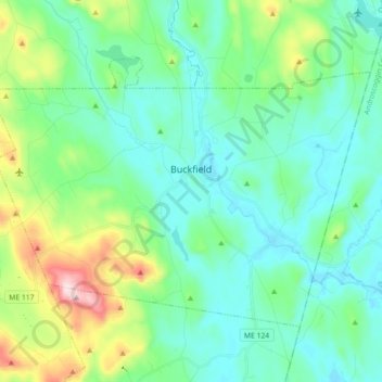
Name: Buckfield topographic map, elevation, terrain.
Location: Buckfield, Oxford County, Maine, 04220, United States (44.23726 -70.45970 44.32774 -70.28151)
Average elevation: 187 m
Minimum elevation: 90 m
Maximum elevation: 532 m
Thank you for supporting this site ❤️
Make a donation
Make a donation
Other topographic maps
Click on a map to view its topography, its elevation and its terrain.
Sturtevant Pond
United States > Maine > Oxford County > Magalloway Plantation
Average elevation: 406 m
Mad River Falls
United States > Maine > Oxford County > Batchelders Grant Township
Average elevation: 495 m
Thank you for supporting this site ❤️
Make a donation
Make a donation