
Thank you for supporting this site ❤️
Make a donation
Make a donation
Fairfield Bay topographic map
Click on the map to display elevation.
Thank you for supporting this site ❤️
Make a donation
Make a donation
About this map
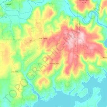
Name: Fairfield Bay topographic map, elevation, terrain.
Average elevation: 230 m
Minimum elevation: 133 m
Maximum elevation: 386 m
Thank you for supporting this site ❤️
Make a donation
Make a donation
Other topographic maps
Click on a map to view its topography, its elevation and its terrain.
Fairfield Bay
United States > Arkansas > Van Buren County > Fairfield Bay > Fairfield Bay
Average elevation: 225 m