
Make a donation
Cagayan de Oro topographic map
Click on the map to display elevation.
Make a donation
About this map
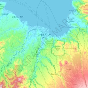
Name: Cagayan de Oro topographic map, elevation, terrain.
Location: Cagayan de Oro, Northern Mindanao, 9000, Philippines (8.25182 124.44721 8.62942 124.79667)
Average elevation: 224 m
Minimum elevation: -4 m
Maximum elevation: 1,000 m
Make a donation
Other topographic maps
Click on a map to view its topography, its elevation and its terrain.
Quezon City
Founded as a pueblo by Saint Pedro Bautista in 1590, San Francisco del Monte may be considered Quezon City's oldest district. The original land area of the old town of San Francisco del Monte was approximately2.5 square kilometres (1.0 sq mi) and covered parts of what is currently known as Project 7 and 8 and…
Average elevation: 57 m
Bantay
It has an average elevation of 100 meters (328.08 feet), with a land area of 7,660 hectares (18,900 acres). It is an elevated and hilly municipality but some barangays, especially those near creeks, are prone to flooding during heavy typhoons.
Average elevation: 8 m
Make a donation
Make a donation
Bacolod
Bacólod (English: Bacolod), is derived from bakólod (Old Spelling: bacólod), the Old Hiligaynon (Old Ilonggo) (Old Spelling: Ylongo and Ilongo) word for a "hill, turtle, mound, rise, hillock, down, any small eminence or elevation", since the resettlement was founded on a stony, hilly area, now the barangay…
Average elevation: 49 m
Cabangan
The municipality has a varied topography characterized by high mountains to narrow coastal plains. The most outstanding feature observable in the municipality is the Zambales Range.
Average elevation: 52 m
Baguio
In 1903, Filipinos, Japanese and Chinese workers were hired to build Kennon Road, the first road directly connecting Baguio with the lowlands of La Union and Pangasinan. Before this, the only road to Benguet was Naguilian Road, and it was largely a horse trail at higher elevations. Camp John Hay was…
Average elevation: 881 m
Make a donation
Tagaytay
The southern and eastern portions of Tagaytay are covered by hills and mountains which is generally forests, pine trees and open grasslands. The city lies along Tagaytay Ridge, a ridge stretching about 32 kilometres (20 mi) from Mount Batulao in the west to Mount Sungay in the east with elevations averaging…
Average elevation: 229 m
Make a donation
Vigan
Vigan is situated in a Quaternary Age sedimentary plain called the Vigan-Bantay Plain which is part of the Ilocos coastal plain. The Vigan-Bantay Plain is bounded on the east by a moderately rugged Miocene sediments consisting of interbedded sandstones and shale to very rugged Meta-volcanics and Meta sediment…
Average elevation: 63 m
Make a donation
Malolos
Malolos is relatively flat of about 0.81% to a gently sloping of 2.17%. The slope of the land descends towards west, southwest to southern direction. The highest land elevation is at about 6.0 meters above sea level while the lowest is only half a meter below sea level. A network of natural waterways and…
Average elevation: 6 m
Make a donation
Pinabacdao
For administrative and statistical convenience, barangays are group into two districts - the Pinabacdao East District and Pinabacdao West District. The East district is composed of barangays situated in high altitude areas or those located in the eastern part of the municipality. Barangays located along…
Average elevation: 11 m
Make a donation
Make a donation
Valenzuela
The highest elevation point is 38 meters (125 ft) above sea level. Having a surface gradient of 0.55% and a gentle slope, hilly landscape is located in the industrial section of the city in Canumay. The average elevation point is 2 meters (6.6 ft) above sea level.
Average elevation: 24 m
Make a donation
Make a donation
Make a donation
Make a donation
Make a donation
Valencia
Philippines > Negros Oriental > Valencia
Valencia occupies an area of 14,749 hectares (36,450 acres), 35% of which are classified as plains. The town is 65% mountainous, with elevation averaging from 200 to 500 metres (660 to 1,640 ft) above sea level, with the top of Mount Talinis at an elevation of 1,903 metres (6,243 ft) along the municipal…
Average elevation: 250 m
Jabonga
Philippines > Agusan del Norte
The topography of the land features plain to rolling and hills. Among the municipalities, Jabonga ranks first in total area and number of farms (464) mostly owned by individuals. It has one of the 36 crop storage facilities of the province. Its major crops are coconut, rice, corn, timber and both fresh and…
Average elevation: 116 m
Legazpi
Legazpi's topography is generally plain on the northeastern areas, with slopes ranging from five to fifteen degrees. The southern areas have mostly rolling to hilly terrain. In the city's coastal areas, the terrain varies from plain (north) to hilly (south). Legazpi is criss-crossed by several rivers including…
Average elevation: 150 m
Make a donation
Make a donation
Naguilian
The approximate elevation of the municipality is 165 meters above sea level. It has the ninth highest approximate average elevation among the twenty (20) towns of the province. The portion with the highest elevation is 544 meters above sea level while the lowest is 10 meters. The slopes range from 2–7% in…
Average elevation: 85 m
Tagum
One of the significant accomplishments of the officialdom of Tagum during the 1990s was its elevation from a second to the first-class municipality. This opened a gateway to increase its financial resources through the Internal Revenue Allocation (IRA) from the national government and local revenues. This was…
Average elevation: 103 m
Kibungan
The municipality is within a cool highland mountainous zone with elevations at more than 2,500 metres (8,200 ft) above sea level. During its coolest months of December to January, Barangay Madaymen experiences chilling temperature of 0 °C (32 °F), causing the famous Frost of Madaymen.
Average elevation: 1,249 m
Make a donation
Make a donation
Make a donation
Make a donation
Mount Banahaw
Philippines > Quezon > Tayabas
The andesitic Banahaw volcanic complex is composed of several stratovolcanoes with Mount Banahaw, the largest with a maximum elevation of 2,170 metres (7,119 ft) above mean sea level. The summit is topped by a 1.5 by 3.5 kilometres (0.93 mi × 2.17 mi) and 210 metres (690 ft) deep crater that is breached on…
Average elevation: 1,730 m
Make a donation
Mandaue
It is one of the two (the other one being the municipality of Consolacion) local government units located within the mainland Metro Cebu where the elevation of land is less than 100 m (330 ft).
Average elevation: 109 m
Make a donation
Antipolo
Its higher elevation than that of Metro Manila affords it a scenic view of the metropolis, especially at night. Its locally grown mangoes and cashews are popular among tourists, as well as suman – a local delicacy made out of glutinous rice. The Hinulugang Taktak National Park, which was once a popular…
Average elevation: 125 m
Zamboanga City
Philippines > Zamboanga Peninsula > Zamboanga City
The overall topography of the city could be described as rolling to very steep. There are some flat lands, mostly narrow strips along the east coast. The urban center is mostly flat with a gentle slope to the interior, ranging from 0 to 3%. The highest registered elevation is 1,200 metres. In terms of slope, a…
Average elevation: 83 m
Make a donation
Make a donation
Make a donation
Angeles
Sapangbato is the largest barangay in Angeles in terms of territory, with a total land area of 104,694 sq. meters and a population of 11,262. Located northwest of Angeles near Clark Freeport Zone, it is identified as the barangay in Angeles with the highest elevation of 750 feet above sea level. It is home to…
Average elevation: 128 m
Make a donation