
Westerholt topographic map
Interactive map
Click on the map to display elevation.
About this map
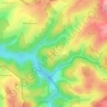
Name: Westerholt topographic map, elevation, terrain.
Average elevation: 370 m
Minimum elevation: 303 m
Maximum elevation: 432 m
Other topographic maps
Click on a map to view its topography, its elevation and its terrain.
Ennepetalsperre
Deutschland > Nordrhein-Westfalen > Breckerfeld
Ennepetalsperre, (X3), Breckerfeld, Ennepe-Ruhr-Kreis, Regierungsbezirk Arnsberg, Nordrhein-Westfalen, 58339, Deutschland
Average elevation: 347 m