
Make a donation
Big Moose topographic map
Click on the map to display elevation.
Make a donation
About this map
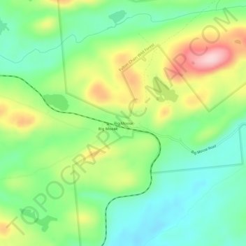
Name: Big Moose topographic map, elevation, terrain.
Average elevation: 620 m
Minimum elevation: 542 m
Maximum elevation: 752 m
Make a donation
Other topographic maps
Click on a map to view its topography, its elevation and its terrain.
Salisbury Center
United States > New York > Herkimer County > Town of Salisbury > Salisbury Center
Average elevation: 334 m
Fulton Chain Wild Forest
United States > New York > Herkimer County > Old Forge
Average elevation: 583 m
Make a donation
Village of Middleville
United States > New York > Herkimer County > Town of Fairfield
Average elevation: 227 m
Village of Cold Brook
United States > New York > Herkimer County > Town of Russia
Average elevation: 327 m
Make a donation
Make a donation
Make a donation
Village of Middleville
United States > New York > Herkimer County > Town of Fairfield
Average elevation: 227 m
Salisbury Center
United States > New York > Herkimer County > Town of Salisbury > Salisbury Center
Average elevation: 337 m
Make a donation