
Thank you for supporting this site ❤️
Make a donation
Make a donation
Konzen topographic map
Click on the map to display elevation.
Thank you for supporting this site ❤️
Make a donation
Make a donation
Konzen
Konzen liegt am Vennbahn Rad- und Wanderweg Aachen-Ulflingen. Neben den Wetterschutzhecken aus Buchen bilden Wanderungen im Hohen Venn die touristischen und landschaftlichen Höhepunkte des Ortes.
Thank you for supporting this site ❤️
Make a donation
Make a donation
About this map
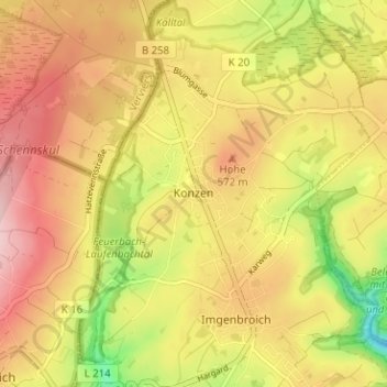
Name: Konzen topographic map, elevation, terrain.
Average elevation: 543 m
Minimum elevation: 435 m
Maximum elevation: 623 m
Thank you for supporting this site ❤️
Make a donation
Make a donation
Other topographic maps
Click on a map to view its topography, its elevation and its terrain.
Troisdorfer Weiher
Deutschland > Nordrhein-Westfalen > Städteregion Aachen > Monschau > Konzen
Average elevation: 546 m
Kalltal
Deutschland > Nordrhein-Westfalen > Städteregion Aachen > Monschau > Entenpfuhl
Average elevation: 552 m