
Thank you for supporting this site ❤️
Make a donation
Make a donation
Neuhaus am Randen topographic map
Click on the map to display elevation.
Thank you for supporting this site ❤️
Make a donation
Make a donation
About this map
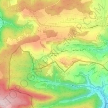
Name: Neuhaus am Randen topographic map, elevation, terrain.
Average elevation: 763 m
Minimum elevation: 586 m
Maximum elevation: 927 m
Thank you for supporting this site ❤️
Make a donation
Make a donation
Other topographic maps
Click on a map to view its topography, its elevation and its terrain.
Riedöschingen
Deutschland > Baden-Württemberg > Schwarzwald-Baar-Kreis > Blumberg
Average elevation: 765 m
Hondingen
Deutschland > Baden-Württemberg > Schwarzwald-Baar-Kreis > Blumberg
Average elevation: 783 m