
Thank you for supporting this site ❤️
Make a donation
Make a donation
Lydell Heights topographic map
Click on the map to display elevation.
Thank you for supporting this site ❤️
Make a donation
Make a donation
About this map
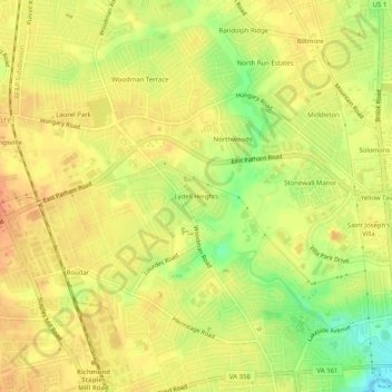
Name: Lydell Heights topographic map, elevation, terrain.
Average elevation: 60 m
Minimum elevation: 33 m
Maximum elevation: 74 m
Thank you for supporting this site ❤️
Make a donation
Make a donation
Other topographic maps
Click on a map to view its topography, its elevation and its terrain.
Canterbury Lake
United States > Virginia > Henrico County > Tuckahoe > Canterbury
Average elevation: 58 m
Canterbury Dam
United States > Virginia > Henrico County > Tuckahoe > Canterbury
Average elevation: 57 m
Thank you for supporting this site ❤️
Make a donation
Make a donation