
Thank you for supporting this site ❤️
Make a donation
Make a donation
Halmstads kommun topographic map
Click on the map to display elevation.
Thank you for supporting this site ❤️
Make a donation
Make a donation
About this map
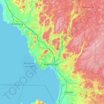
Name: Halmstads kommun topographic map, elevation, terrain.
Location: Halmstads kommun, Halland County, Sweden (56.54237 12.24084 56.94445 13.32519)
Average elevation: 65 m
Minimum elevation: 0 m
Maximum elevation: 216 m
Thank you for supporting this site ❤️
Make a donation
Make a donation
Other topographic maps
Click on a map to view its topography, its elevation and its terrain.