
Thank you for supporting this site ❤️
Make a donation
Make a donation
Broadbent topographic map
Click on the map to display elevation.
Thank you for supporting this site ❤️
Make a donation
Make a donation
About this map
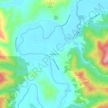
Name: Broadbent topographic map, elevation, terrain.
Location: Broadbent, Coos County, Oregon, 97414, United States (42.98886 -124.16659 43.02886 -124.12659)
Average elevation: 68 m
Minimum elevation: 5 m
Maximum elevation: 276 m
Thank you for supporting this site ❤️
Make a donation
Make a donation
Other topographic maps
Click on a map to view its topography, its elevation and its terrain.