
Thank you for supporting this site ❤️
Make a donation
Make a donation
Alba topographic map
Click on the map to display elevation.
Thank you for supporting this site ❤️
Make a donation
Make a donation
About this map
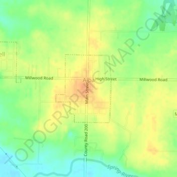
Name: Alba topographic map, elevation, terrain.
Location: Alba, Jasper County, Missouri, 64830, United States (37.23185 -94.42376 37.24225 -94.41319)
Average elevation: 291 m
Minimum elevation: 271 m
Maximum elevation: 307 m
Thank you for supporting this site ❤️
Make a donation
Make a donation
Other topographic maps
Click on a map to view its topography, its elevation and its terrain.