
Calafate topographic map
Interactive map
Click on the map to display elevation.
About this map
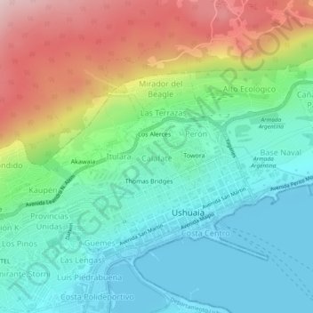
Name: Calafate topographic map, elevation, terrain.
Location: Calafate, Ushuaia, Terra do Fogo, Argentina (-54.80399 -68.31613 -54.80023 -68.30746)
Average elevation: 98 m
Minimum elevation: 0 m
Maximum elevation: 295 m
Other topographic maps
Click on a map to view its topography, its elevation and its terrain.
Parque
Argentina > Terra do Fogo > Ushuaia
Parque, Ushuaia, Terra do Fogo, Argentina
Average elevation: 64 m