
Thank you for supporting this site ❤️
Make a donation
Make a donation
Alum Cave topographic map
Click on the map to display elevation.
Thank you for supporting this site ❤️
Make a donation
Make a donation
About this map
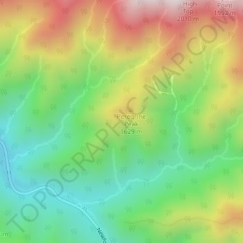
Name: Alum Cave topographic map, elevation, terrain.
Location: Alum Cave, Sevier County, Tennessee, United States (35.63872 -83.44598 35.63882 -83.44588)
Average elevation: 1,451 m
Minimum elevation: 1,123 m
Maximum elevation: 1,928 m
Thank you for supporting this site ❤️
Make a donation
Make a donation
Other topographic maps
Click on a map to view its topography, its elevation and its terrain.
Douglas Dam
United States > Tennessee > Sevier County
The Douglas Project required the construction of ten smaller, earthen saddle dams to fill in gaps along the adjacent ridgeline and permit a higher water elevation than would otherwise be possible. Most of these saddle dams are located in the hills southeast of the main dam. One protects downtown Dandridge,…
Average elevation: 312 m