
Thank you for supporting this site ❤️
Make a donation
Make a donation
Tai Wai Village topographic map
Click on the map to display elevation.
Thank you for supporting this site ❤️
Make a donation
Make a donation
About this map
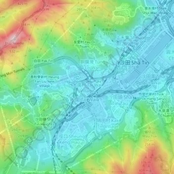
Name: Tai Wai Village topographic map, elevation, terrain.
Location: Tai Wai Village, Tai Wai Hui, Hong Kong, China (22.35572 114.15872 22.39572 114.19872)
Average elevation: 131 m
Minimum elevation: -3 m
Maximum elevation: 487 m
Thank you for supporting this site ❤️
Make a donation
Make a donation
Other topographic maps
Click on a map to view its topography, its elevation and its terrain.
Thank you for supporting this site ❤️
Make a donation
Make a donation
Thank you for supporting this site ❤️
Make a donation
Make a donation
Thank you for supporting this site ❤️
Make a donation
Make a donation
Thank you for supporting this site ❤️
Make a donation
Make a donation
Thank you for supporting this site ❤️
Make a donation
Make a donation