
Thank you for supporting this site ❤️
Make a donation
Make a donation
Taranaki Maunga topographic map
Click on the map to display elevation.
Thank you for supporting this site ❤️
Make a donation
Make a donation
About this map
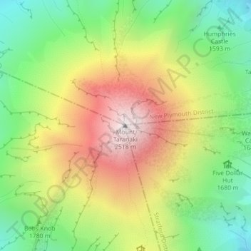
Name: Taranaki Maunga topographic map, elevation, terrain.
Location: Taranaki Maunga, Stratford District, Taranaki, New Zealand (-39.29613 174.06384 -39.29603 174.06394)
Average elevation: 1,847 m
Minimum elevation: 1,328 m
Maximum elevation: 2,495 m
Thank you for supporting this site ❤️
Make a donation
Make a donation