
Morne A Bruler topographic map
Interactive map
Click on the map to display elevation.
About this map
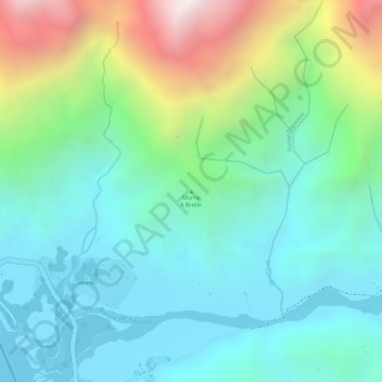
Name: Morne A Bruler topographic map, elevation, terrain.
Average elevation: 268 m
Minimum elevation: 0 m
Maximum elevation: 918 m
Other topographic maps
Click on a map to view its topography, its elevation and its terrain.
Chamblain
Haïti > Département du Sud > Tiburon
Chamblain, 4e Dalmette, Tiburon, Arrondissement des Chardonnières, Département du Sud, Haïti
Average elevation: 143 m
ravine seche
Haïti > Département du Sud > Tiburon
ravine seche, 3e Loby, Tiburon, Arrondissement des Chardonnières, Département du Sud, Haïti
Average elevation: 219 m