
Thank you for supporting this site ❤️
Make a donation
Make a donation
Poppenweiler topographic map
Click on the map to display elevation.
Thank you for supporting this site ❤️
Make a donation
Make a donation
About this map
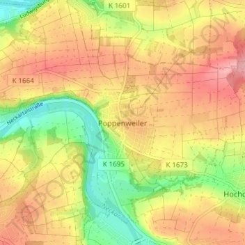
Name: Poppenweiler topographic map, elevation, terrain.
Average elevation: 260 m
Minimum elevation: 193 m
Maximum elevation: 314 m
Thank you for supporting this site ❤️
Make a donation
Make a donation
Other topographic maps
Click on a map to view its topography, its elevation and its terrain.
Pflugfelden
Deutschland > Baden-Württemberg > Landkreis Ludwigsburg > Ludwigsburg
Average elevation: 315 m
Poppenweiler
Deutschland > Baden-Württemberg > Landkreis Ludwigsburg > Ludwigsburg > Poppenweiler
Average elevation: 262 m
Eglosheim
Deutschland > Baden-Württemberg > Landkreis Ludwigsburg > Ludwigsburg
Average elevation: 268 m
Neckarweihingen
Deutschland > Baden-Württemberg > Landkreis Ludwigsburg > Ludwigsburg
Average elevation: 243 m
Thank you for supporting this site ❤️
Make a donation
Make a donation
Favoritepark
Deutschland > Baden-Württemberg > Landkreis Ludwigsburg > Ludwigsburg
Average elevation: 272 m
Thank you for supporting this site ❤️
Make a donation
Make a donation