
Thank you for supporting this site ❤️
Make a donation
Make a donation
Huntsville topographic map
Click on the map to display elevation.
Thank you for supporting this site ❤️
Make a donation
Make a donation
About this map
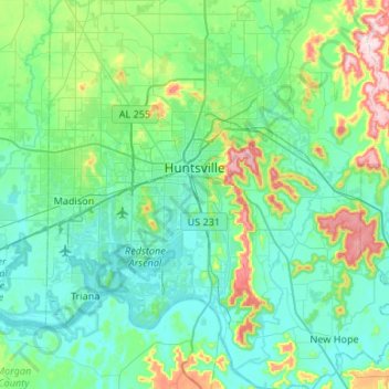
Name: Huntsville topographic map, elevation, terrain.
Location: Huntsville, Madison County, Alabama, United States (34.53343 -86.95678 34.86516 -86.39934)
Average elevation: 232 m
Minimum elevation: 166 m
Maximum elevation: 546 m
Thank you for supporting this site ❤️
Make a donation
Make a donation
Other topographic maps
Click on a map to view its topography, its elevation and its terrain.