
Make a donation
Ogunquit topographic map
Click on the map to display elevation.
Make a donation
Ogunquit
According to the United States Census Bureau, the town has a total area of 15.25 square miles (39.50 km2), of which 4.18 square miles (10.83 km2) is land and 11.07 square miles (28.67 km2) is water. Ogunquit is drained by the Josias and Ogunquit Rivers. The highest elevation in town is just over 160 feet (49 m) above sea level, in several locations. The lowest elevation is sea level, along the Atlantic Ocean coastline.
Make a donation
About this map
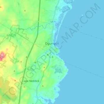
Name: Ogunquit topographic map, elevation, terrain.
Location: Ogunquit, York County, Maine, 03907, United States (43.20814 -70.65119 43.27175 -70.50230)
Average elevation: 25 m
Minimum elevation: -7 m
Maximum elevation: 153 m
Make a donation
Other topographic maps
Click on a map to view its topography, its elevation and its terrain.
Make a donation
Make a donation