
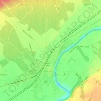
Le Chemin Vert topographic map
Interactive map
Click on the map to display elevation.
About this map
Name: Le Chemin Vert topographic map, elevation, terrain.
Average elevation: 131 m
Minimum elevation: 100 m
Maximum elevation: 164 m
Other topographic maps
Click on a map to view its topography, its elevation and its terrain.
Saurs
France > Occitanie > Tarn > Lisle-sur-Tarn
Saurs, Lisle-sur-Tarn, Albi, Tarn, Occitanie, France métropolitaine, 81310, France
Average elevation: 182 m
Maison Forestière de Sivens
France > Occitanie > Tarn > Lisle-sur-Tarn
Maison Forestière de Sivens, Lisle-sur-Tarn, Albi, Tarn, Occitanie, France métropolitaine, 81310, France
Average elevation: 233 m
Mazou
France > Occitanie > Tarn > Lisle-sur-Tarn
Mazou, Lisle-sur-Tarn, Albi, Tarn, Occitanie, France métropolitaine, 81310, France
Average elevation: 156 m
Les Cassarous
France > Occitanie > Tarn > Lisle-sur-Tarn
Les Cassarous, Lisle-sur-Tarn, Albi, Tarn, Occitanie, France métropolitaine, 81310, France
Average elevation: 133 m
Montaigut
France > Occitanie > Tarn > Lisle-sur-Tarn
Montaigut, Lisle-sur-Tarn, Albi, Tarn, Occitanie, France métropolitaine, 81310, France
Average elevation: 194 m
Lagassat
France > Occitanie > Tarn > Lisle-sur-Tarn
Lagassat, Lisle-sur-Tarn, Albi, Tarn, Occitanie, France métropolitaine, 81310, France
Average elevation: 165 m