
Thank you for supporting this site ❤️
Make a donation
Make a donation
Sultan Bathery topographic map
Click on the map to display elevation.
Thank you for supporting this site ❤️
Make a donation
Make a donation
Sultan Bathery
Sultan Bathery is located at 11°40′N 76°17′E / 11.67°N 76.28°E / 11.67; 76.28, on the Kozhikode–Kollegal National Highway (NH 766) 97 kilometers from Kozhikode. It is 114 km from Mysore and about 100 km from Ooty (Udagamandalam). It is also connected with Nilambur. It has an average elevation of 907 m (2,976 ft).
Thank you for supporting this site ❤️
Make a donation
Make a donation
About this map
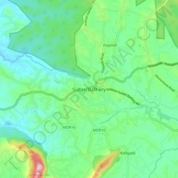
Name: Sultan Bathery topographic map, elevation, terrain.
Location: Sultan Bathery, Sulthanbathery, Wayanad, Kerala, 673592, India (11.62319 76.21955 11.70319 76.29955)
Average elevation: 876 m
Minimum elevation: 776 m
Maximum elevation: 1,185 m
Thank you for supporting this site ❤️
Make a donation
Make a donation
Other topographic maps
Click on a map to view its topography, its elevation and its terrain.
Thank you for supporting this site ❤️
Make a donation
Make a donation
Thank you for supporting this site ❤️
Make a donation
Make a donation