
Thank you for supporting this site ❤️
Make a donation
Make a donation
French Street topographic map
Click on the map to display elevation.
Thank you for supporting this site ❤️
Make a donation
Make a donation
About this map
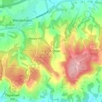
Name: French Street topographic map, elevation, terrain.
Average elevation: 153 m
Minimum elevation: 88 m
Maximum elevation: 244 m
Thank you for supporting this site ❤️
Make a donation
Make a donation
Other topographic maps
Click on a map to view its topography, its elevation and its terrain.
West Kingsdown
Vereinigtes Königreich > England > Kent > Sevenoaks > West Kingsdown
Average elevation: 154 m