
Thank you for supporting this site ❤️
Make a donation
Make a donation
Seingbouse topographic map
Click on the map to display elevation.
Thank you for supporting this site ❤️
Make a donation
Make a donation
Seingbouse
Située à 9 ;kmau nord-est de Saint-Avold, la commune culmine à 300 mètres d'altitude.
Thank you for supporting this site ❤️
Make a donation
Make a donation
About this map
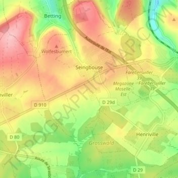
Name: Seingbouse topographic map, elevation, terrain.
Average elevation: 293 m
Minimum elevation: 218 m
Maximum elevation: 363 m
Thank you for supporting this site ❤️
Make a donation
Make a donation
Other topographic maps
Click on a map to view its topography, its elevation and its terrain.